Trimble has made a new addition to its office software by introducing Trimble® Business Center version 3.40 and it provides huge advantages to the geospatial professionals.
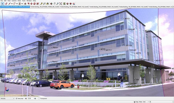
Trimble Business Center 3.40 facilitates the users who perform with their visual data to export assembled images into SketchUp Pro and produce realistic 3D models of buildings, bridges and diversified other objects. The users will be able to carry out direct modeling out of images as well as handle data, generate deliverables instantly.
With Trimble Business Center 3.40 the users can easily extract objects all along vertical walls like façade reconstruction in quickest possible way. Besides, the users get the ability to determine and sketch line work perfect in dimension directly on the panoramas, abolishing the practice for taking out photo points for making line work.
Trimble Business Center performs as a strong geospatial office software suite that can deal with, evaluate and process all field survey data ranging from optical, GNSS and imaging data. This newest application facilitates the geospatial professionals to perform with imaging and optical data in the office. Some significant improvements include using the Trimble V10 Imaging Rover devoid of a positioning sensor; superior image processing capability in complicated areas; functionality to export visual data into SketchUp Pro; and generating dimensionally correct measurements from a plane. All these features empower the geospatial professionals to produce convincing deliverables effectively for their clients.
There are also supplementary applications like interior mapping, bridge inspection, and crime and crash scene investigation included in Trimble Business Center 3.40 useful for both geospatial and non-geospatial professionals.
The users can access Trimble Business Center version 3.40 in November 2014 through Trimble's Geospatial Distribution Channel.

~~~~~~~~~~~~~~~~~~~~~~~~
Published By
Rajib Dey
~~~~~~~~~~~~~~~~~~~~~~~~
No comments:
Post a Comment